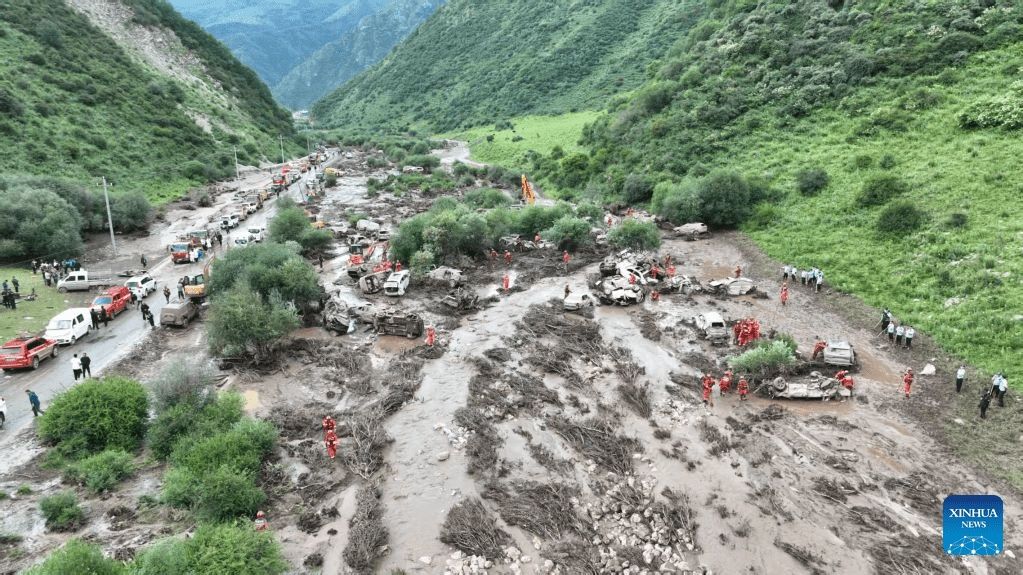
A catastrophic flash flood engulfed a popular scenic area in Weiyuan County, Dingxi City in Gansu Province on Sunday afternoon, resulting in at least 10 deaths and 23 injuries as emergency authorities raced against time to locate missing persons. The sudden deluge caught tourists and camping visitors off guard, trapping groups within the scenic area as water levels rose rapidly without warning. By early evening, rescue teams from local public security and fire-and-rescue departments had mobilized across the affected zone, launching intensive search-and-rescue operations that continued into the night.
The disaster unfolded as Typhoon Noul, the most powerful cyclone to hit China this year, made landfall near Huidong County in Guangdong Province at approximately 3:50 a.m. on Sunday, triggering severe weather patterns across a vast swathe of the country. Named after the Korean term for the glow of sunrise or sunset, the twelfth tropical cyclone of the season swept through Guangdong and Hong Kong with destructive gale-force winds before pushing inland. The combined impact of the typhoon's moisture-laden systems and orographic lifting in mountainous regions created the atmospheric conditions that led to the catastrophic rainfall event in the northwest.
The magnitude of the threat prompted Chinese authorities to issue their highest-level alert for flash-flood disasters across multiple provinces. The joint red warning issued by the Ministry of Water Resources and the China Meteorological Administration covered expected hazardous conditions stretching from Sunday evening through Monday evening across Jiangxi, Hunan, Guangdong, Sichuan, Shaanxi, Gansu and parts of southeastern Xinjiang. Officials warned residents to maintain constant vigilance regarding real-time flood monitoring systems, evacuation orders and risk-prevention protocols as rainfall was forecast to persist until Tuesday, with some areas including Fujian Province bracing for extraordinarily heavy downpours.
The typhoon's approach forced one of the largest climate-related evacuations in recent Chinese history. Authorities relocated more than 700,000 people from Guangdong Province alone as preparation measures ahead of the storm's arrival. Such unprecedented displacement operations reflect the scale and intensity of Typhoon Noul, which marked the third significant typhoon event to impact China within a single month. The coordinated response demonstrated the sophistication of China's disaster management systems, yet the Gansu incident underscores the challenges in protecting remote scenic areas and transient tourist populations during rapidly developing hazardous weather.
In Hong Kong, the storm's initial impact proved severe but manageable through established protocols. The territory experienced sustained southwesterly gales as Typhoon Noul passed within 80 kilometres of the Asian financial hub. However, meteorological improvements allowed authorities to progressively cancel all typhoon warning signals by Sunday evening. Hong Kong's airport resumed gradual flight operations during the afternoon after suspending services for more than twelve hours—a precautionary measure that protected aircraft and passengers from dangerous crosswind conditions while the system remained proximate.
Government agencies throughout the affected regions issued urgent directives for local administrations to intensify surveillance of flood-prone terrain, particularly mountain valleys, riverbank regions, construction zones and bridge approaches where water accumulation and structural instability pose amplified dangers. These geographical zones present compounding risks during extreme rainfall events, where steep gradients accelerate water flow and narrow channels concentrate discharge volumes. Construction sites remain especially vulnerable due to exposed foundations, temporary drainage systems and concentrations of equipment and personnel in low-lying positions.
The meteorological progression of Typhoon Noul as it traversed inland demonstrated the typical weakening pattern of tropical systems encountering continental landmasses and higher-elevation terrain. Hong Kong's Observatory confirmed gradual intensity reduction as the typhoon moved deeper into Guangdong, though wind speeds remained hazardous for extended periods. State broadcaster CCTV projected sustained precipitation and strong winds throughout the affected zones as the system's circulation continued its inland trajectory, maintaining moisture delivery mechanisms even as central pressure increased and rotational intensity diminished.
The tragedy in Gansu carries significant implications for Southeast Asian nations and regional tourism authorities. Scenic areas throughout the region hosting international and domestic visitors face similar vulnerabilities during extreme weather events, particularly when monsoon systems or tropical cyclones interact with complex topography. The incident highlights critical gaps in real-time hazard communication to transient populations such as tourists and campers who may lack familiarity with local geographical hazards and early-warning systems. Resort operators, park authorities and tourism boards across Malaysia, Thailand, Indonesia and other Southeast Asian destinations should review emergency protocols and communication procedures to ensure rapid alerting and evacuation guidance during rapidly intensifying weather situations.
China's response framework, encompassing coordinated meteorological monitoring, multi-level alert systems and inter-agency rescue operations, reflects regional best practices that adjacent nations can adapt to local contexts. The combination of technological capacity, institutional coordination and public communication mechanisms demonstrated during Typhoon Noul's passage offers instructive models for regional disaster preparedness, though implementation challenges persist in protecting remote areas and transient populations. For Malaysian authorities and regional partners monitoring typhoon seasons, the Gansu incident provides sobering evidence that even well-developed economies with sophisticated early-warning infrastructure face substantial challenges when extreme weather events develop rapidly in areas with limited accessibility or vulnerable populations.

