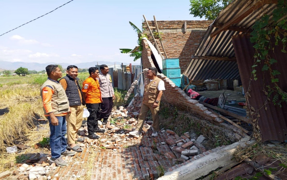
A devastating magnitude 7.7 earthquake struck Indonesia's Flores Island in East Nusa Tenggara province in the early hours of Saturday, triggering a major humanitarian response and leaving thousands displaced. The National Disaster Management Agency (BNPB) confirmed that roughly 2,000 residents have either been formally evacuated by government agencies or have independently sought safety following the violent tremors and the tsunami warning that followed. The scale of the displacement underscores both the immediate danger posed by the seismic event and the precarious situation facing communities in one of Indonesia's most earthquake-prone regions.
According to Berton Suar Pelita Panjaitan, the BNPB's acting chief of the Disaster Data, Information and Communication Centre, the majority of residents managed to reach safety either through official evacuation protocols or by their own initiative after experiencing the powerful shaking and heeding tsunami alerts. The agency's rapid response reflected the established disaster management procedures in a nation accustomed to frequent seismic activity along the Pacific Ring of Fire. However, officials emphasised that comprehensive damage assessments were still underway across multiple affected localities, with the full extent of destruction not yet fully quantified.
The earthquake's violent motion struck at 4.58 am local time, with seismologists pinpointing the epicentre in the ocean approximately 30 kilometres from the town of Mbay at a relatively shallow depth of 15 kilometres. Such shallow-focus earthquakes typically transmit more energy to the surface, explaining the significant damage and the immediate concern for tsunami generation. The Meteorology, Climatology and Geophysics Agency (BMKG) issued a tsunami warning in the immediate aftermath, though sea-level monitoring stations eventually showed no dangerous wave formation, leading authorities to lift the alert at 7.31 am.
Initial casualty figures reported by the Maumere Search and Rescue Office revealed a sobering toll: 20 people had lost their lives, with six others sustaining injuries and two individuals trapped in collapsed structures. These numbers, while preliminary, reflected the catastrophic potential of major earthquakes in densely populated areas and the ongoing risks facing rescue teams as they worked to locate any remaining survivors among the rubble. The figures were expected to evolve as search operations continued and affected areas became fully accessible.
Structural damage across Flores proved substantial and widespread. Preliminary field surveys documented 54 houses suffering severe destruction, nine experiencing moderate damage, and 11 sustaining minor harm. Beyond residential structures, critical infrastructure sustained significant hits: five health facilities, essential for treating earthquake victims and the injured; one educational institution; three places of worship serving as community gathering points; a warehouse belonging to Bulog, Indonesia's state food logistics agency; and six government administrative offices. The damage to medical facilities was particularly concerning given the immediate medical needs of the injured and the disruption to healthcare services in the aftermath.
The Manggarai district emerged as one of the hardest-hit zones, with 29 houses completely destroyed, nine moderately damaged, and nine experiencing lighter damage. The neighbouring East Manggarai district also suffered severely with 23 houses reduced to ruins. These two districts absorbed the brunt of the earthquake's destructive energy, likely owing to their proximity to the epicentre and the geological characteristics of local soil and bedrock. The concentration of damage in these areas meant that relief efforts would need to prioritise these zones for emergency assistance and reconstruction planning.
Communications infrastructure also bore the impact of the seismic event. By 7 am on Saturday, authorities had identified approximately 200 base transceiver station (BTS) sites experiencing service disruptions across 10 districts and cities throughout East Nusa Tenggara. According to the Ministry of Communication and Digital Affairs, these affected sites represented 16.35 per cent of all BTS infrastructure in the impacted zones. Such telecommunications disruptions severely hampered emergency response coordination, public warnings, and families' ability to confirm the safety of loved ones—a critical challenge in the early hours following a major disaster.
Wayan Toni Supriyanto, the ministry's Digital Infrastructure director-general, acknowledged the telecommunications crisis and revealed that the government was actively coordinating with mobile network operators to restore services as quickly as possible. The restoration of communications networks would prove essential for coordinating relief efforts, disseminating emergency information, and allowing affected populations to reconnect with families and access aid services. The involvement of private telecommunications companies alongside government agencies reflected the reality that modern disaster response requires partnerships across public and private sectors.
The intensity of aftershock activity compounded the trauma and complexity of the relief response. A total of 111 aftershocks were recorded following the main tremor, a characteristic pattern of seismic unrest that kept affected populations in a state of heightened anxiety and vulnerability. Aftershocks, while typically weaker than the main event, can trigger additional collapses of already-damaged structures, complicate rescue operations, and trigger psychological distress among survivors. The sustained seismic activity forced authorities to maintain heightened vigilance and meant that buildings previously deemed marginally habitable might require evacuation.
Regional disaster management agencies, military personnel, police forces, and local government officials mobilised rapidly to assess damage, verify casualty figures, and begin addressing immediate humanitarian needs. The comprehensive multi-agency approach reflected Indonesia's experience managing frequent natural disasters and the established protocols for coordinating responses across national, provincial, and district levels. Teams on the ground faced the dual challenges of documenting damage accurately while simultaneously providing emergency aid to displaced populations.
For Malaysia and neighbouring Southeast Asian nations, the Flores earthquake served as a stark reminder of the region's seismic vulnerability and the importance of investment in disaster preparedness, early warning systems, and international mutual assistance frameworks. The incident demonstrated how a single major earthquake could displace thousands, disrupt essential services, and strain limited local resources within hours. The coordinated response by Indonesian authorities, despite the scale of displacement and damage, highlighted both the necessity and the challenges of managing major disasters in developing regions where infrastructure remains vulnerable to natural hazards.
As investigations continued into the causes and impacts of the earthquake, attention would inevitably turn to the longer-term reconstruction needs, the resilience of Flores's critical infrastructure, and whether the disaster would catalyse improvements to building codes and emergency preparedness in one of Indonesia's most seismically active provinces. The displacement of 2,000 residents, the destruction across multiple districts, and the ongoing aftershock sequence painted a picture of a community facing extended disruption and the protracted challenges of disaster recovery.

