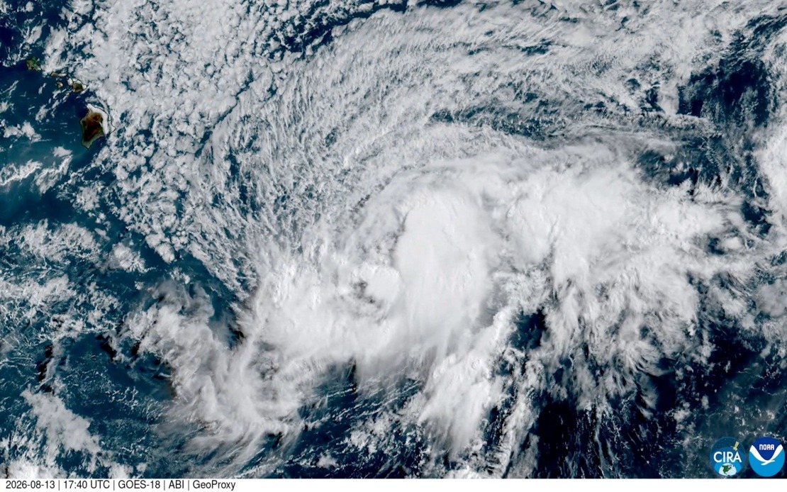
Hawaii's Big Island is preparing for what could become a historic natural disaster this weekend, with Tropical Storm Lala expected to strengthen into a full hurricane before making landfall—an event that has not occurred on the island for more than a century and a half. The National Hurricane Centre's latest projections indicate that Lala should reach hurricane strength by the time it approaches the Big Island on Saturday, marking a rare and potentially catastrophic weather event for the Hawaiian archipelago. Such an occurrence underscores the vulnerability of Pacific island communities to tropical cyclones and raises important questions about disaster preparedness in geographically isolated regions.
The meteorological significance of this event cannot be overstated. According to Vanessa Almanza, a meteorologist with the National Weather Service in Honolulu, the last confirmed hurricane to make landfall on the Big Island occurred in 1871, when a Category 3 storm struck the northeast corner of the island. Almanza's reference to satellite-era observations highlights an important distinction: while historical records exist dating back nearly 150 years, the absence of modern meteorological instruments during that earlier period means contemporary forecasters lack the precise data that would allow them to fully understand the island's hurricane vulnerability. The research conducted by University of Hawaii atmospheric scientists examining newspaper archives from 1871 provides the most reliable historical baseline available, yet it also reveals how incomplete our understanding of pre-satellite weather patterns remains.
The current threat posed by Tropical Storm Lala extends beyond wind damage alone. Forecasters warn that the system will deliver exceptionally heavy rainfall, which poses the dual hazard of destructive flooding across lowland areas and moisture-laden conditions that paradoxically increase wildfire risk in higher elevations and leeward slopes. This combination of water and fire represents a particularly challenging scenario for emergency management agencies, as resources may need to be divided between flood response and wildfire suppression simultaneously. For communities in the Pacific, such compound disasters complicate evacuation planning and resource allocation in ways that mainland hurricane preparedness protocols may not adequately address.
The National Hurricane Centre issued a full hurricane warning for the Big Island itself, while tropical storm warnings extend to Maui County—a designation that encompasses the islands of Maui, Molokai, Lanai, and Kahoolawe. This tiered warning system reflects the anticipated severity gradient of the storm system, with the Big Island facing the most acute danger while neighbouring islands in Maui County require heightened alert status. The geographical proximity of these islands means that residents across the broader archipelago will experience some level of impact, though the Big Island remains the focal point of concern.
For Malaysian and Southeast Asian observers, this development carries instructive lessons about tropical cyclone management in island nations. The Hawaiian Islands, despite being part of a developed nation with advanced meteorological infrastructure and disaster response capabilities, still face significant vulnerability to major hurricanes. This reality underscores that geographic isolation and exposure to tropical cyclone belts present inherent challenges that technological advancement and economic resources can mitigate but not eliminate. Southeast Asian nations, many of which lie within similar latitudes and cyclone-prone regions, can observe how Hawaii's experience with long-term hurricane risks informs contemporary preparedness strategies.
The 1871 precedent provides limited guidance for modern planners, partly because historical hurricane impacts cannot be directly extrapolated to contemporary conditions. Population densities, building codes, infrastructure networks, and economic interdependencies have transformed dramatically over 150 years. A hurricane of similar intensity to the 1871 event would have vastly different consequences today, affecting not only residential areas but also critical infrastructure including airports, ports, power generation facilities, and communication networks upon which modern island economies depend. The Big Island's economy, substantially tied to tourism and agriculture, faces potential disruption that extends beyond immediate physical damage to include market confidence and supply chain interruptions.
Early warning systems represent one of the primary defences available to island communities facing such threats. The ability to forecast Lala's intensification trajectory with sufficient lead time allows residents and businesses to implement protective measures, secure loose objects that could become dangerous projectiles, reinforce structures, and position emergency response resources strategically. However, the compressed timeline from tropical storm to hurricane status underscores the rapid intensification potential of tropical cyclones over warm ocean waters—a phenomenon that has become increasingly recognised in climate research as potentially more frequent under warming ocean conditions.
The absence of a mainland hurricane for the Big Island since 1871 might create a false sense of security among some residents, particularly younger generations who have no personal memory of major hurricane impacts. This historical gap can translate into inadequate preparedness if individuals underestimate the risks or assume that the long interval means another occurrence is unlikely soon. Conversely, the rare nature of the threat may motivate heightened attention to preparedness protocols that could benefit the community regardless of whether Lala reaches hurricane strength as currently forecast.
For the broader Pacific region, including Southeast Asia, monitoring how the Hawaiian Islands manage this rare weather emergency provides practical insights into emergency coordination, resource mobilisation, and community resilience. The isolation that makes island nations vulnerable also creates opportunities for consolidated disaster response efforts, as evacuation routes and resource distribution points are limited and therefore more manageable than in large continental territories. Yet this same isolation means that external assistance takes longer to arrive, placing premium value on local preparedness, self-sufficiency, and internal resource management.

