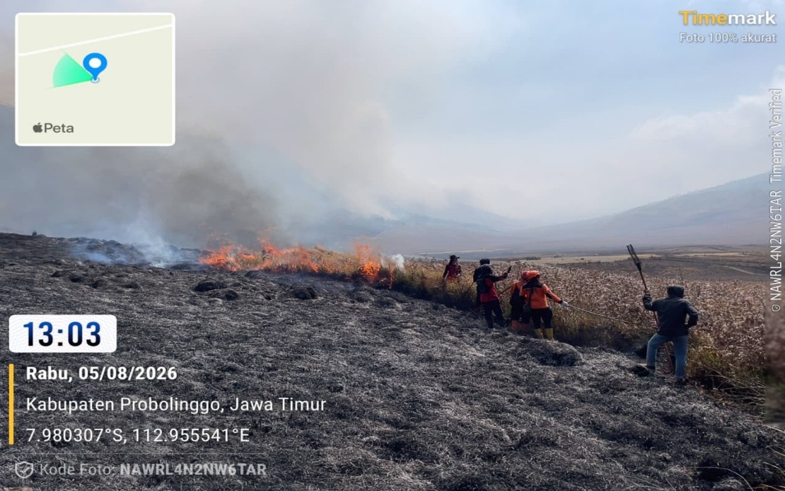
Indonesia's National Disaster Management Agency has escalated its response to a major wildfire at Mount Bromo by deploying air support to supplement ground efforts, as the blaze continues to ravage vast stretches of forest across East Java's vulnerable landscape. The fire, which ignited on Monday, has already consumed around 60 hectares of vegetation across Probolinggo Regency and the Bromo Tengger Semeru National Park in the adjoining Malang Regency, prompting authorities to bring in two water-bombing helicopters for precision aerial drops in areas inaccessible to conventional firefighting teams.
According to Abdul Muhari, head of the National Disaster Management Agency's Disaster Data, Information and Communication Centre, the destruction has split unevenly across the affected zones, with approximately 10 hectares burned in Probolinggo Regency alone and a considerably larger swath of 50 hectares consumed within the boundaries of the Bromo Tengger Semeru National Park. The deployment of helicopter support represents a critical tactical shift, as the fire's geography presents severe challenges for ground-based suppression teams. The mountainous terrain and steep slopes surrounding Mount Bromo have proven prohibitively difficult for firefighters operating on foot, leaving numerous hotspots festering in inaccessible locations that conventional brigades simply cannot reach safely or efficiently.
While emergency personnel made substantial progress containing the blaze by Wednesday afternoon, bringing much of the visible fire under control, the situation remained precarious with scattered hotspots continuing to burn in the most treacherous terrain. The persistence of these pockets of fire underscores the complexity of combating wildfire in mountainous environments, where topography creates natural barriers to comprehensive suppression efforts. Abdul Muhari confirmed that monitoring operations were ongoing and that response teams would maintain active engagement with remaining hotspots as long as necessary to achieve complete extinguishment.
Beyond aerial support, Indonesia's disaster management authorities are preparing a weather modification operation as an additional layer of response, contingent upon prevailing atmospheric conditions. This intervention strategy, commonly deployed in Southeast Asia during critical fire situations, would involve seeding clouds to induce rainfall over the affected Mount Bromo region, thereby complementing the ground and air operations already underway. Such coordinated multi-pronged approaches represent the standard playbook for large-scale wildfire incidents in Indonesia, where the country's diverse and challenging geography frequently demands innovative and layered responses.
The closure of portions of the Mount Bromo tourist zone remains in effect indefinitely, with authorities maintaining strict access restrictions to safeguard both the ongoing firefighting operations and the general public. Mount Bromo, one of Indonesia's most visited natural attractions and a globally recognized iconic volcano straddling the Malang-Probolinggo border, typically draws significant visitor numbers throughout the year. The extended closure, while economically impactful for local tourism operators and communities dependent on visitor spending, reflects the seriousness authorities attribute to the hazards posed by active wildfire conditions in the area.
Investigations into the fire's origin point toward human negligence, with preliminary findings suggesting that the blaze may have been triggered when hikers abandoned an inadequately extinguished campfire. This assessment, though not yet conclusively proven, aligns with patterns evident across Indonesia and the broader Southeast Asian region, where unattended or improperly managed recreational fires frequently spark larger conflagrations that overwhelm suppression capacity. The ongoing investigation aims to establish precise causation, which could have implications for enforcement of safety regulations and visitor education protocols at the national park.
The Mount Bromo incident highlights the persistent vulnerability of Indonesia's protected forest zones to catastrophic fire damage, particularly during periods of elevated fire risk. The Bromo Tengger Semeru National Park, established to preserve critical ecosystems and geological features, faces mounting pressure from human activity in surrounding areas, with tourism, agriculture, and settlement expansion creating interfaces where unintended fire ignition becomes an ever-present threat. The speed with which 60 hectares burned across multiple jurisdictions underscores how rapidly fire can propagate in national park environments where vegetation density and accumulated fuel loads remain high.
For Malaysia and other Southeast Asian nations, the Mount Bromo incident serves as a stark reminder of transnational fire risk dynamics. While the current fire remains geographically isolated to East Java, the region's fire seasons and smoke impacts have historically affected air quality and atmospheric conditions across maritime Southeast Asia, including Malaysian territory. Indonesia's investment in air support capacity and weather modification capabilities reflects broader regional commitments to reducing catastrophic wildfire outcomes, a priority increasingly shared across ASEAN as climate variability amplifies fire season intensity and duration.
The multi-agency coordination evident in the Mount Bromo response, involving the National Disaster Management Agency, local authorities in both regencies, and the national park administration, demonstrates the institutional mechanisms Indonesia has developed to address such crises. However, the incident also exposes the limitations of reactive firefighting approaches, suggesting that prevention-focused strategies—particularly enhanced visitor education, campfire regulation enforcement, and landscape management practices—warrant equal investment and attention. As climate patterns shift and tourism pressures intensify across Southeast Asia's protected natural areas, the balance between access, conservation, and disaster prevention will shape both environmental outcomes and economic viability for communities throughout the region.

