Japan's meteorological authority issued urgent warnings on Friday as two separate typhoons converged on the archipelago, with Typhoon Higos expected to make landfall over the weekend and Typhoon Mekkhala already pressing toward populated regions. The dual storm system has prompted widespread evacuation protocols and severe weather alerts across much of the nation, while heavy downpours continue to drench western and eastern territories.
The Japan Meteorological Agency identified Typhoon Mekkhala as an immediate threat, having already reached the Amami region in Kagoshima Prefecture in southwestern Japan by Friday. Weather forecasters anticipated its northeastward progression toward the densely populated Kanto region, where millions of residents faced potential exposure to extreme weather. Meanwhile, Typhoon Higos approached from the Pacific, positioned to strike the country's southern coast and venture further inland across central and eastern prefectures throughout Saturday.
Authorities have declared an unprecedented scale of preventive evacuation, with the Fire and Disaster Management Agency confirming that over 2 million residents across 13 prefectures in the Kinki and Kyushu regions were placed under mandatory evacuation orders as of 7 am Friday. In Seika, Kyoto Prefecture, local officials escalated emergency protocols to Level 5, the highest safety alert tier, following a confirmed landslide that struck the town during Friday morning hours. These precautionary measures reflect the severity officials anticipate from the converging storm systems.
Rainfall accumulations across affected areas have already reached dangerous levels in the days preceding the dual landfall. The city of Goto in Nagasaki Prefecture recorded 600 millimetres of precipitation between Tuesday and Friday morning, while the Aso region in Kumamoto Prefecture and Ureshino in Saga Prefecture each accumulated more than 500 millimetres during the same period. Such intense moisture delivery has saturated soil conditions throughout southwestern Japan, substantially elevating the risk of secondary hazards including landslides and flooding.
Meteorologists cautioned that rainfall intensity would escalate significantly as both typhoons make their final approaches. The Tokai region faces forecasts of up to 300 millimetres by noon Saturday, while the Kanto-Koshin region extends across a broader area expecting approximately 150 millimetres. These projections indicate that already-waterlogged terrain will receive substantial additional precipitation during the critical 24-hour window when both systems exert maximum influence over Japanese territory.
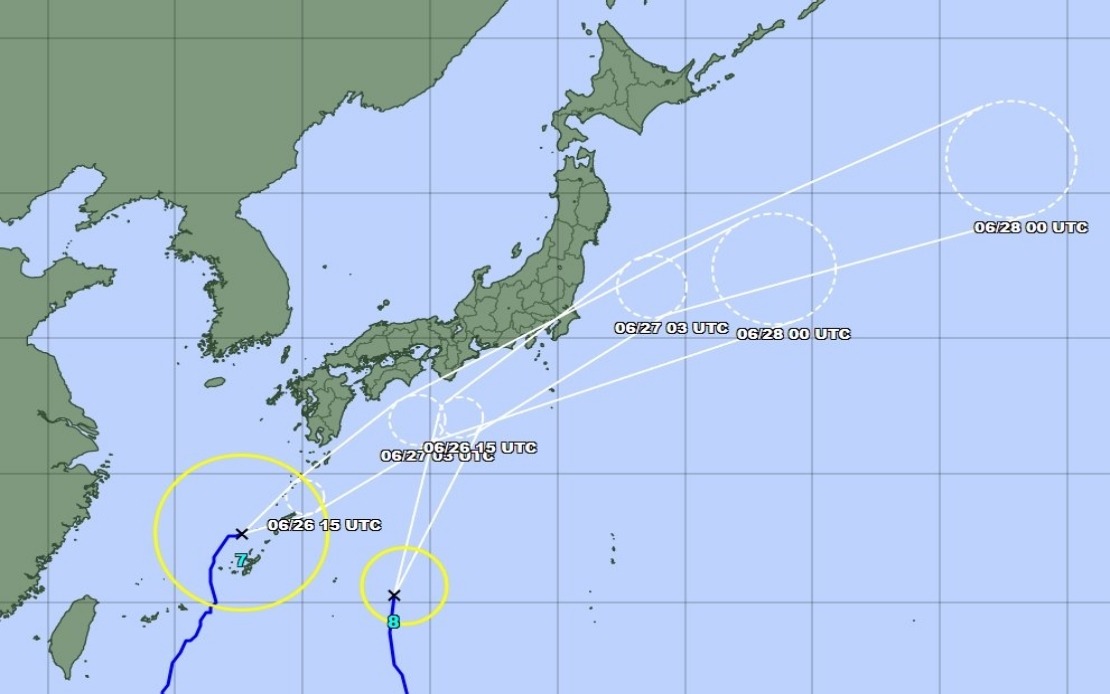
The positioning of Typhoon Mekkhala as of 11 am Friday demonstrated its continued progression toward central Japan. Located off Okinawa's Kume Island, the system moved northeastward at 15 kilometres per hour, maintaining a trajectory that would carry it through some of Japan's most densely populated metropolitan corridors. The Kanto region, encompassing Tokyo and surrounding prefectures, represents perhaps the greatest exposure point given both Mekkhala's projected path and Higos's anticipated movement after landfall.
The Japan Meteorological Agency tempered expectations regarding the storms' ultimate intensity, predicting that both typhoons would gradually weaken into extratropical cyclones following their approach to or landfall on Japanese soil. Extratropical systems, while typically less organized than tropical cyclones, nevertheless retain destructive potential particularly in areas already saturated by preceding rainfall. The agency's prediction did not diminish urgent warnings about flooding and landslide hazards.
For Malaysian readers and the broader Southeast Asian region, the double typhoon situation underscores the region's exposure to intense seasonal weather systems. Japan's well-developed disaster response infrastructure—including multiple meteorological agencies, rapid evacuation protocols, and communication systems capable of reaching millions—demonstrates institutional preparedness that contrasts sharply with capacities in less-developed nations. The coordination required to evacuate over 2 million people across multiple prefectures represents organizational capability that remains aspirational for many developing countries facing similar climatic challenges.
The convergence of two separate typhoons simultaneously represents a compounding risk scenario that meteorologists anticipated would produce rainfall, wind, and secondary hazard impacts exceeding what either system might generate independently. Japanese authorities' decision to institute massive preventive evacuations reflects a risk-averse approach prioritizing life safety over economic disruption—a calculation that differs markedly from responses in some developing economies where evacuation costs and implementation challenges create institutional resistance to proactive measures.
Beyond Japan's borders, the typhoon activity demonstrates the region's integration within broader Pacific weather patterns. Southeast Asian nations including the Philippines, Thailand, and Vietnam have experienced comparable storms, though typically with less-robust institutional responses and greater humanitarian consequences. The lessons from Japan's dual-typhoon management—including early warning dissemination, cross-prefectural coordination, and public compliance with evacuation orders—offer operational templates that regional partners continue evaluating for domestic adaptation.
The weekend timeline for Higos's landfall creates a compressed window for final preparations. Residents in projected impact zones faced rapidly narrowing opportunity to secure property, finalize travel arrangements, and position themselves in designated shelters. The public alert system's effectiveness during this critical period would substantially influence casualty figures and property damage extent.