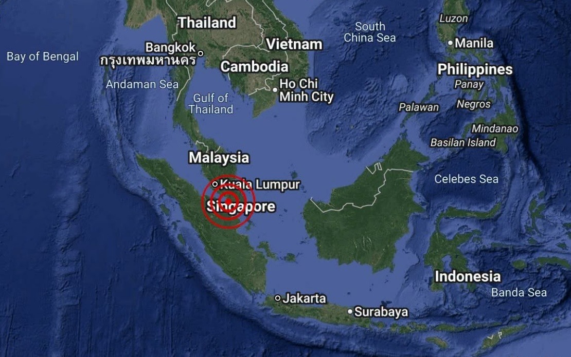
A minor seismic event took place in the waters off Batu Pahat in Johor on August 25, with the Malaysian Meteorological Department recording a magnitude of 3.1. The tremor struck at 4.12 pm, with its epicentre positioned at 1.7 degrees north latitude and 102.8 degrees east longitude, approximately 18 kilometres southwest of the coastal town. The National Weather and Earthquake Operations Centre, operating under MetMalaysia, issued an immediate assessment of the incident.
The earthquake, though detectable by seismic monitoring equipment, falls within the range of weak tremors that typically cause minimal concern for populated areas. Earthquakes of this magnitude are common occurrences in the Southeast Asian region, where tectonic activity along various fault lines generates regular seismic events of varying intensities. Malaysia's position relative to these geological structures means the country occasionally experiences such tremors, though major earthquakes remain comparatively rare.
Authorities moved swiftly to provide public reassurance following the event. MetMalaysia's statement explicitly confirmed the absence of any tsunami threat to Malaysian waters and coastal communities. This assessment reflects established protocols whereby earthquakes occurring offshore at relatively shallow depths are evaluated for their potential to generate dangerous ocean waves. In this instance, the magnitude and location of the tremor fell below thresholds that would typically trigger such secondary hazards.
The Batu Pahat area, located in Johor's southwestern region along the Straits of Malacca, is home to significant fishing communities and industrial operations. Any seismic activity in this vicinity naturally draws local attention and requires swift official communication to prevent unnecessary alarm. The rapid response from MetMalaysia reflects standard operating procedures designed to keep the public informed while preventing public panic.
For residents across Johor and neighbouring states, such minor earthquakes are largely imperceptible in daily life. The 3.1-magnitude reading suggests that ground shaking would have been minimal to non-existent for most inhabitants, with only sensitive seismic instruments and persons in close proximity to the epicentre potentially detecting any movement. This contrasts sharply with more significant seismic events that can cause structural damage and pose serious hazards to communities.
The offshore location of this earthquake distinguishes it from terrestrial tremors that might affect populated urban centres. Water acts as an effective medium for dissipating seismic energy in many cases, and the marine environment surrounding Batu Pahat provides natural buffering against the transmission of ground vibrations to inhabited areas. This geographical advantage has historically protected Malaysian coastal communities from experiencing severe earthquake-related damage despite periodic seismic activity in surrounding waters.
Regional geological context is relevant for understanding such occurrences. The broader Southeast Asian zone sits at the intersection of several tectonic plates and features numerous active fault systems, particularly around Indonesia and the Philippines. While Malaysia itself experiences fewer major earthquakes than its neighbours, the nation remains susceptible to secondary effects from large tremors originating in nearby regions. Individual events like the Batu Pahat occurrence provide opportunities for authorities to test monitoring systems and public communication protocols.
MetMalaysia's monitoring capabilities continue to evolve with technological advancement, allowing for increasingly precise detection and analysis of seismic events across Malaysian territory and surrounding waters. The department maintains a network of seismic stations that operate continuously to identify and characterise earthquakes. This infrastructure serves dual purposes: providing immediate hazard assessment and contributing to long-term understanding of Malaysia's seismic environment through accumulated data.
The absence of a tsunami threat in this instance reflects both the earthquake's moderate magnitude and its depth profile. Tsunamis are typically generated by sudden, large-scale vertical displacement of the seafloor, usually associated with more powerful earthquakes along subduction zones. The Batu Pahat event, occurring at a different tectonic setting, did not produce the conditions necessary for such secondary disasters. Nevertheless, MetMalaysia's explicit statement provides clear guidance to fishermen, maritime operators, and coastal residents, enabling them to proceed normally with their activities.
Public awareness of earthquake monitoring and hazard communication has grown substantially in Malaysia over recent years, particularly following major regional seismic events that affected neighbouring countries. This enhanced understanding helps communities respond appropriately to official announcements and distinguishes between routine seismic activity and genuine threats. Educational initiatives by meteorological and disaster management agencies have contributed to more sophisticated public literacy regarding natural hazards.
The incident underscores the importance of maintaining robust systems for earthquake detection and swift official communication. Even minor tremors generate public interest and concern, particularly in areas with maritime industries and populations living near the coast. Clear, timely information from authoritative sources prevents the spread of misinformation and maintains public confidence in government institutions' ability to protect citizens from natural disasters.

