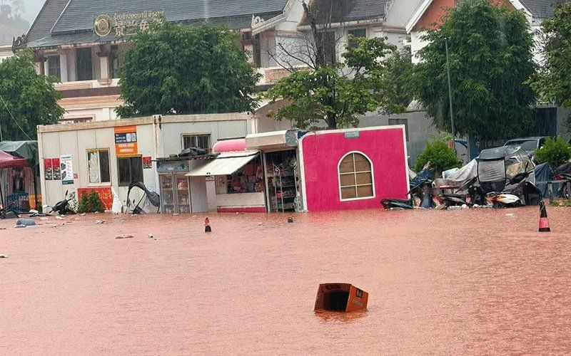
Northern Laos slipped into crisis mode on Saturday as Luang Namtha province officially declared itself a disaster zone following torrential flash floods that tore through its districts and surrounding areas. The declaration came after widespread inundation swept across more than thirty villages in the Luang Namtha and Nalae districts, with particular devastation centred around the Boten special economic zone at the Laos-China border crossing. The flooding submerged buildings, farmland and crucial infrastructure across a broad geographical area, though authorities confirmed that the border checkpoint itself escaped the worst damage.
The catastrophic flooding was triggered by a cascade of heavy rainfall upstream that swelled several rivers beyond their safe levels. The Tha River, a critical waterway in the region, surged dramatically as accumulated rainfall pushed water volumes southward into Laotian territory. By Saturday, hydrological measurements at a monitoring station on the Tha River recorded water levels reaching 6.58 metres—substantially above the standard 6-metre flood alert threshold and dangerously approaching the critical 7-metre flood level that signals acute danger. This rapid escalation of water levels left little time for affected communities to prepare for the sudden onslaught.
The meteorological and hydrological agencies under Laos's Ministry of Agriculture and Environment responded swiftly by issuing formal flood warnings for the Tha River system covering the weekend period of August 29-30. These warnings reflected growing concerns that water levels might continue their upward trajectory. Recognising the urgency, provincial administrators in five districts received orders to begin alerting residents in zones most vulnerable to continued flooding—those residing near riverbanks, in low-lying terrain and other environmentally precarious locations. Authorities instructed these communities to prepare contingency plans for possible evacuation should water levels rise further.
The Luang Namtha Provincial Administrative Committee's disaster declaration represented a formal acknowledgment that the flooding had exceeded normal response capacity and required coordinated provincial support. Local officials throughout the affected zone received directives to maintain constant vigilance over the evolving situation, to respond with urgency to emerging incidents and to maintain regular reporting channels with provincial leadership. The flood warning underscored the broader environmental threat as multiple factors converged—heavy rainfall, rising river systems and geographical vulnerability—creating perfect conditions for cascade failures across the region's infrastructure.
Beyond Luang Namtha, the meteorological threat extended across a much wider geographical canvas. A larger warning encompassing fourteen provinces across northern and central Laos was issued for the weekend period, reflecting the broader weather system approaching the region. A low-pressure zone moving across northern Laos and neighbouring southwest China was combining with south-westerly monsoon patterns to create conditions conducive to severe weather. This atmospheric configuration was forecast to produce scattered thunderstorms, moderate to heavy rainfall and potentially damaging wind gusts across an expansive area.
The fourteen provinces identified as facing elevated flood and landslide risk included Phongsaly, Huaphan, Luang Prabang, Luang Namtha, Oudomxay, Xaysomboun, Bolikhamxay, Khammuan, Savannakhet, Salavan, Xekong, Champasak, Attapeu and Vientiane. This geographical spread demonstrated the systemic nature of the weather threat facing the country. The simultaneous risks across this many provinces suggested that emergency response resources would face significant strain as multiple regions potentially required assistance simultaneously.
The damage to the Boten special economic zone held particular significance for Laos's development ambitions. This border trade corridor represents a critical node in regional commerce and bilateral economic integration between Laos and China. While the border checkpoint itself remained operational, disruptions to the surrounding infrastructure and services within the special economic zone could impede trade flows and economic activity in the short term. The flooding of farmland across the region also threatened agricultural livelihoods for rural communities dependent on seasonal harvests.
For regional observers, the flooding highlighted the vulnerability of Laotian infrastructure to extreme weather events and the limitations of existing disaster preparedness systems. The rapid escalation from heavy rainfall to critical flood levels underscored how quickly environmental disasters can overwhelm response capacity in developing nations. The warning system and evacuation protocols, while activated, represented reactive measures rather than preventive infrastructure improvements that might mitigate future disasters.
The broader context of climate variability in Southeast Asia rendered Laos particularly susceptible to such events. As a landlocked nation characterised by mountainous terrain and river-dependent communities, Laos faces inherent hydrological challenges. Flash flooding in upstream areas translates directly into downstream hazards for populated regions. The convergence of monsoonal patterns with low-pressure systems created the type of meteorological conditions that have become increasingly frequent across the region during recent decades.
The situation demanded coordinated response not only within Laos but potentially involving cross-border coordination with China, given that the low-pressure system's impact extended into Chinese territory. Upstream management of water flow from Chinese tributaries could influence downstream impacts in Laos, making transnational cooperation essential for effective disaster management. The incident thus underscored the interconnected nature of hydrological risks in the Mekong basin region and the necessity for regional collaboration in water management and early warning systems.

