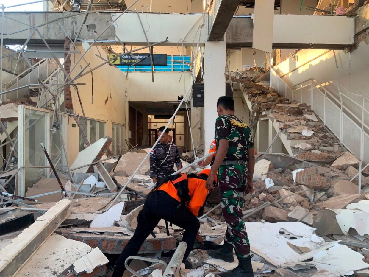
A devastating magnitude 7.7 earthquake struck the coast of Indonesia's Flores region in the early hours of Saturday, August 15, toppling buildings and homes across the island and claiming at least two lives. The powerful tremor sent residents fleeing into the streets and prompted emergency evacuations at hospitals throughout the affected area, underscoring the vulnerability of communities in one of the world's most seismically active zones. Initial reports confirmed significant structural damage across multiple locations, with search and rescue teams mobilizing to assess the full extent of the destruction and identify additional casualties.
According to the U.S. Geological Survey, the quake reached a depth of 10 kilometres and struck at 5:58 a.m. local time with its epicenter located approximately 68 kilometres north-northwest of Ende, the largest city in East Nusa Tenggara province. The Maumere Search and Rescue Agency reported that two residents died and two others sustained injuries as a result of the earthquake's violent ground motion and the collapse of numerous structures. The initial tremor was followed by multiple aftershocks, each capable of causing additional damage to already-compromised buildings and heightening anxiety among residents still processing the initial impact.
Indonesian authorities immediately activated an early warning system, issuing a tsunami alert that applied to several eastern provinces including East Nusa Tenggara, West Nusa Tenggara, South Sulawesi, and Southeast Sulawesi. Coastal residents received urgent instructions to vacate beaches and riverbanks and move to elevated terrain as a precaution against potential sea-level surges. The swift response reflected lessons learned from past catastrophes, though the agency's monitoring technology ultimately determined that the shallow undersea earthquake did not generate dangerous waves, leading officials to cancel the warning within hours of its issuance.
The human cost of the disaster became immediately apparent through eyewitness accounts and video footage emerging from the region. Yohanna Embu, a resident of Sikka regency, described scenes of panic as the ground shook violently, with frightened residents dashing towards higher elevations while buildings crumbled around them. She specifically noted the collapse of the waiting room at Maumere's port terminal, a structure that would normally serve as a gathering point for travellers and cargo handlers. Local television coverage captured harrowing images of hospital staff urgently evacuating patients from affected buildings, relocating beds, intravenous stands, and oxygen cylinders to hastily-constructed outdoor treatment zones to ensure continuity of care despite the emergency.
Among the most distressing incidents reported was the partial collapse of a roof at St. Peter Major Seminary, known locally as Ritapiret Seminary, during morning Mass services. The structure, located in Sikka and historically significant to the predominantly Catholic island, partially gave way as students and nuns attended the religious ceremony. According to Rev. Guidelbertus Tanga, the rector of the seminary, panicked worshippers fled beneath falling debris as the building failed. The chaos resulted in at least one priest sustaining a broken leg after attempting to escape by jumping from the second floor, an injury that underscores both the violence of the tremor and the desperate choices people faced in trying to reach safety.
Flores island, lying along the eastern boundary of the Lesser Sunda Islands, experienced the most pronounced shaking due to its proximity to the epicenter. Early assessments indicated widespread damage across residential and commercial properties, with structural failures reported in multiple municipalities. The preliminary damage surveys conducted by local authorities suggested that numerous buildings sustained significant compromise to their integrity, posing ongoing hazards to inhabitants and complicating rescue operations in the immediate aftermath. The concentration of damage in populated areas highlighted the serious consequences when major seismic events occur near urban settlements.
The tragedy serves as another stark reminder of Indonesia's precarious geological position. The world's largest archipelago, comprising more than 17,000 islands stretching across three time zones, sits directly atop the Pacific Ring of Fire, a horseshoe-shaped region notorious for its concentration of volcanic systems and crustal fracture zones. This positioning guarantees that Indonesia will continue experiencing frequent earthquakes, many of significant magnitude, making disaster preparedness and building code enforcement critical national priorities. The region experiences thousands of tremors annually, though most remain too minor to cause appreciable damage or trigger warning systems.
The historical record provides sobering context for understanding the region's seismic dangers. In December 1992, Flores was devastated by a catastrophic earthquake and the tsunami it generated, a combination that killed approximately 2,500 people and caused immense economic losses across the southeastern island. That disaster, one of Indonesia's deadliest natural catastrophes in recent decades, established the template for current emergency response protocols and prompted investments in monitoring infrastructure. Yet despite these measures and the passage of three decades, the August 2024 earthquake demonstrated that even sophisticated early warning systems cannot eliminate vulnerability, particularly when buildings lack adequate seismic engineering standards.
For Southeast Asian readers and policymakers, the recurring pattern of destructive earthquakes in Indonesia carries important implications. The region's geological instability means that neighbouring countries must maintain robust disaster assistance agreements and cross-border coordination mechanisms to respond effectively when major events occur. The interconnected nature of regional supply chains, maritime commerce, and tourism means that significant disruptions in Indonesia can reverberate throughout Southeast Asia's broader economy. Furthermore, the persistent challenge of retrofitting older structures and enforcing modern building codes in developing areas remains unresolved despite multiple cycles of disaster and reconstruction, suggesting that technical solutions alone prove insufficient without complementary investments in urban planning and public education.
The immediate focus for authorities centred on verifying casualty counts, locating any persons trapped beneath collapsed debris, and preventing secondary disasters such as fires or disease outbreaks that frequently follow major earthquakes. Medical facilities required careful assessment to ensure they could continue operating despite damage sustained during the initial tremor, since hospitals would inevitably face a surge in patients requiring treatment for injuries. The psychological impact of the earthquake on survivors cannot be overlooked; residents of seismically active zones often experience lasting trauma from repeated exposure to natural hazards, affecting community resilience and mental health outcomes in ways that extend far beyond the immediate physical destruction.

