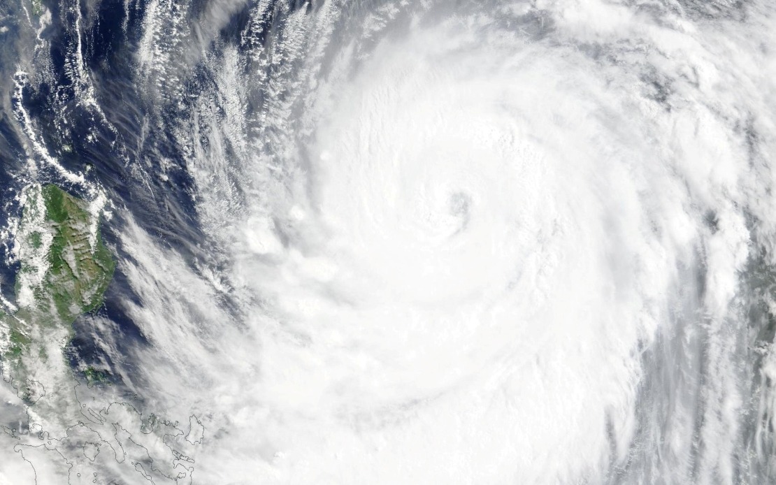
Taiwan's Central Weather Bureau escalated alert status on Thursday afternoon as Typhoon Bavi, marking the ninth significant cyclone to develop in the western Pacific this year, maintained its approach toward the island with steadily increasing wind speeds. Meteorological officials warned that a land warning affecting Taiwan proper would likely be issued early Friday, signalling imminent direct impact across populated coastal regions and major population centres.
The sea warning, put into effect at 2:30 pm local time, encompasses extensive maritime zones surrounding Taiwan, including the waters immediately off the island's northeastern and southeastern coastlines. The alert area extends to encompass Orchid Island and Green Island, two major inhabited island territories under Taiwan's jurisdiction, as well as the strategically important Bashi Channel, which separates Taiwan from the Philippines and represents a vital shipping corridor for regional maritime traffic.
At the time of the warning's issuance, Typhoon Bavi was positioned in the seas southeast of Eluanbi, Taiwan's southernmost geographical point, and was tracking in a northwest direction toward the main island. Current meteorological data indicated the storm possessed maximum sustained winds of 51 metres per second at its centre, with gusts in the most violent zones reaching 63 metres per second, characteristic of a powerful tropical cyclone system capable of causing substantial infrastructure damage.
Forecasters project that Bavi will continue its northwest trajectory at a forward speed of 15 to 20 kilometres per hour, with the storm's track expected to pass north of Taiwan rather than directly over the island's centre. Despite this relatively fortunate positioning, meteorological modelling suggests Taiwan will nevertheless experience typhoon-force conditions, with the system likely to impact the island as either a lower-category strong typhoon or an upper-range moderate typhoon, depending on final intensity fluctuations as it approaches.
The meteorological threat has already begun translating into substantial disruptions to Taiwan's transportation infrastructure and regional connectivity. Airlines operating between Taiwan and Japan's Okinawa prefecture have cancelled the vast majority of scheduled services, effectively severing air links between the two locations during the critical period preceding and immediately following the storm's passage. Several long-haul international flight services, connecting Taiwan to destinations across East and Southeast Asia, have likewise been cancelled as carriers adopt precautionary measures to avoid operating aircraft in deteriorating weather conditions.
Maritime transport has similarly ground to a halt across multiple sectors. Ferry operators serving routes connecting Taiwan to offshore islands and neighboring territories have suspended normal service schedules in anticipation of dangerous sea conditions that would render vessel operation unsafe for passengers and crew. These suspensions particularly affect islanders and commuters who depend on regular ferry connectivity for economic and social purposes.
Terrestrial transportation networks have likewise entered heightened alert status. Mountain roads and elevated terrain routes throughout Taiwan have been placed on heightened alert status, with authorities warning of potential hazards including landslides, debris flows, and severely compromised visibility that could render these passages impassable or dangerous for vehicle traffic. Such precautions reflect the particular vulnerability of Taiwan's topography, where typhoon rainfall frequently triggers geological instability in mountainous regions that constitute much of the island's interior landscape.
For Malaysian and broader Southeast Asian readers, the situation illustrates the continuing vulnerability of island nations and densely populated coastal zones to tropical cyclone systems generated across the western Pacific basin. Taiwan's experience demonstrates how modern meteorological infrastructure and coordinated early-warning systems enable authorities to provide advance notice that permits evacuation, transportation suspension, and protective measures. The disruption to regional air and maritime services underscores how weather events affecting major population centres create cascading effects throughout Southeast Asia's interconnected transportation and logistics networks.
The storm's approach also highlights seasonal patterns familiar throughout the region. July represents a period within the elevated typhoon season for the western Pacific, when atmospheric conditions over tropical oceans consistently generate multiple organized storm systems. Taiwan, positioned directly within the main western Pacific typhoon belt, faces recurring exposure to such systems, contrasting with the generally lower typhoon frequency experienced by Malaysia's equatorial and near-equatorial geography, which situates the country outside the primary development zone for western Pacific tropical cyclones.

