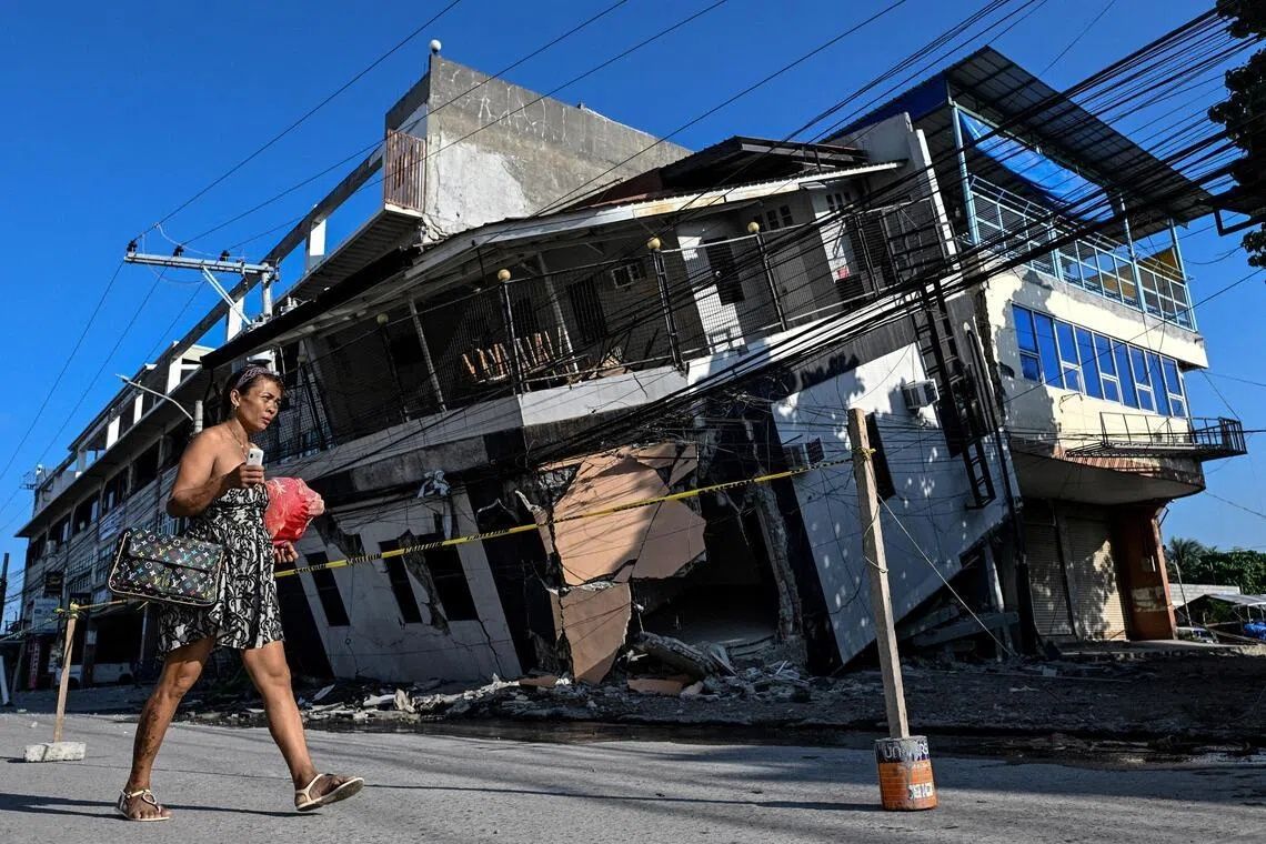
The June 8 earthquake measuring 7.8 on the Richter scale fundamentally altered the landscape of Mindanao's southern coast, an event that has left residents grappling with both immediate safety concerns and the strange reality of living beside a radically transformed shoreline. The tremor, centred near the Cotabato Trench roughly 50 kilometres offshore, killed at least 76 people, triggered numerous landslides, and toppled buildings across the region. Yet beyond the immediate destruction, the seismic forces unleashed a phenomenon that continues to unsettle the area's fishing communities and tourism operators: a dramatic uplifting of the ocean floor that has created new land where water once flowed.
Witnesses to this geological transformation describe an almost surreal experience. Arsenio Butil Jr, a fisherman and pastor in Glan, Sarangani province, was inside his home when the earthquake struck. As the ground shook violently beneath him, he fell to his knees to pray. When the shaking subsided and he opened his eyes, he observed the shoreline morphing before him in real time—vast stretches of coral that had been submerged suddenly thrust above the waterline. The phenomenon, known to geologists as "coastal uplift," occurs when tectonic plates shift upward along fault lines, raising the seabed itself. Butil Jr recalled the water receding and returning repeatedly, perhaps three or four times, while fish died and floated in the confusion.
The physical extent of this transformation is substantial. According to Nane Danlag, a seismologist at the Philippines' seismology centre, the seabed rose approximately two metres in the affected zone. This uplift has extended the coastline by as much as 200 metres in certain areas, a permanent change that has made entire stretches of previously familiar shoreline unrecognisable to families who have lived there for generations. When visiting the area, journalists observed fishing boats that had once been moored at the water's edge now stranded on the wrong side of an imposing wall of jagged, dead coral that stretches for kilometres in both directions. The affected zone extends between two towns separated by nearly 100 kilometres, underscoring the scale of the geological event.
Danlag emphasised that this transformation, while dramatic to witness, represents a natural and recurring geological process. "This has been going on for thousands of years," she stated, stressing that what residents now observe is their permanent new coastline. The Cotabato Trench, which lies in close proximity to Mindanao, sits atop one of the Philippines' most seismically active zones. Notably, a United Nations disaster risk reduction report released in mid-May had warned that a swarm of thousands of minor earthquakes recorded in January could presage a major seismic event—a prediction that proved tragically prescient.
Beyond the geological marvel lies a complex human reality. In the hills overlooking a neighbouring village, approximately 100 people—fishermen, their families, and villagers—remain encamped on higher ground, reluctant to return to their destroyed homes. Datu Atom Malimpnig, a Maguindanaon chieftain, explained that the transformed coastline has instilled deep psychological anxiety among the displaced. Many harbour genuine fears that a tsunami could still strike, and the dramatically altered seabed has only intensified these concerns. The newly exposed coral and changed bathymetry have left residents unconvinced that the danger has fully passed, with some viewing the hilltop encampment as significantly safer than their former coastal settlements. This reluctance to return reflects not merely fear but a rational caution rooted in the unpredictability of seismic zones.
The economic implications extend beyond displacement. Edzel Baylon, an employee at the Isla Jardin del Mar resort situated on this coastline, described the altered landscape as catastrophic for the tourism industry. The resort's primary marketing draw—a pristine white sand beach suitable for swimming and water recreation—has been rendered largely unusable. What once constituted an idyllic beachfront now features a vast expanse of exposed coral separating the resort from deeper water, making the nearshore environment shallow and unsuitable for the swimming and boating activities upon which such destinations depend. The economic disruption to tourism, already fragile in a post-pandemic environment, compounds the broader disaster.
The seismic activity that reshaped this coastline has not ceased. Since the initial June 8 earthquake, more than 8,500 aftershocks have been recorded throughout the region, according to the Philippine seismology agency. These continued tremors have prevented residents from beginning meaningful reconstruction efforts. In Glan, residents acknowledge they must eventually determine their next steps, yet they remain psychologically unprepared to attempt rebuilding. Butil Jr observed that the ground in his area remains cracked with long, deep fissures—physical reminders of the tectonic forces at work. These visible fractures on the earth's surface raise legitimate concerns that another earthquake of comparable magnitude could prove equally or more destructive to hastily reconstructed structures.
The broader context of this event reflects the Philippines' precarious geographical position along the Pacific Ring of Fire. Mindanao, the nation's second-largest island, sits in one of the world's most seismically active regions, where the Philippine, Sunda, and Cotabato trenches converge. For residents of southern Mindanao, earthquakes are not anomalies but recurring elements of existence. However, a 7.8 magnitude event represents a high-impact occurrence capable of permanently altering both landscape and community. The June 8 earthquake stands as a stark reminder of the immense forces that continuously reshape the Earth's crust and the vulnerability of human settlements constructed upon such dynamic geological foundations.
The phenomenon of coastal uplift, while visible and measurable, carries broader implications for the region's future. As climate change drives rising sea levels globally, the temporary seabed uplift in Mindanao offers a counterbalance in this specific locality—though this geological gift provides little comfort to those displaced by the disaster. The new coastline has created previously non-existent land, yet this creation came at tremendous cost: destroyed homes, lost lives, and deeply fractured communities. The transformation of Mindanao's southern shore serves as a powerful illustration of how geology and human habitation intersect, often with tragic consequences, in one of Asia's most seismically dynamic zones.

%22%2F%3E%3C%2Fpattern%3E%3C%2Fdefs%3E%3Crect%20width%3D%22100%25%22%20height%3D%22100%25%22%20fill%3D%22url(%23ph4w4yvg)%22%2F%3E%3Crect%20width%3D%22100%25%22%20height%3D%22100%25%22%20fill%3D%22url(%23ph4w4yvp)%22%2F%3E%3Ctext%20x%3D%2250%25%22%20y%3D%2250%25%22%20text-anchor%3D%22middle%22%20dominant-baseline%3D%22central%22%20fill%3D%22rgba(255%2C255%2C255%2C0.95)%22%20font-family%3D%22Georgia%2C%20'Times%20New%20Roman'%2C%20serif%22%20font-weight%3D%22700%22%20font-size%3D%22226%22%20letter-spacing%3D%22-0.02em%22%3EPenang%3C%2Ftext%3E%3C%2Fsvg%3E)