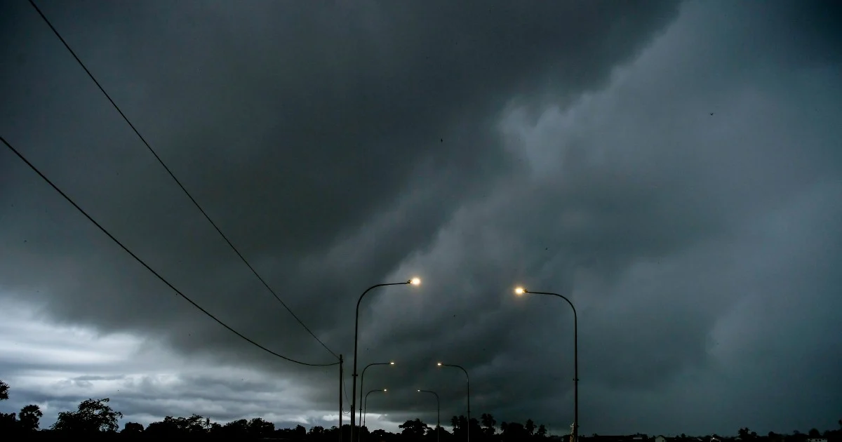
The Malaysian Meteorological Department has activated severe weather warnings across the nation, cautioning residents and travellers to prepare for a day of turbulent atmospheric conditions. The alert encompasses multiple regions spanning Peninsular Malaysia alongside the East Malaysian states of Sabah and Sarawak, with conditions expected to persist throughout the afternoon until 5pm today.
Thunderstorm activity poses particular risks to communities and infrastructure during the alert period. When atmospheric instability reaches critical levels, towering cumulonimbus clouds develop rapidly, producing violent updrafts and downdrafts that spawn torrential precipitation, frequent lightning strikes, and potentially damaging wind gusts. The combination of these elements creates a compound hazard requiring heightened public awareness and preparedness.
Heavy rainfall represents one of the most immediate concerns flagged by MetMalaysia. Such precipitation rates risk saturating ground conditions, particularly in low-lying and flood-prone areas. Urban drainage systems may become overwhelmed, whilst rural communities face potential flash flood scenarios in susceptible watersheds. The timing of the alert—affecting the remainder of the business and school day—means disruptions to transportation networks are likely as roads become congested or temporarily impassable.
Strong winds accompanying the thunderstorms add another dimension to the hazard profile. Wind speeds sufficient to warrant meteorological warnings can damage unsecured structures, uproot trees, down power lines, and create hazardous conditions for high-sided vehicles on exposed highways and bridges. Maritime and coastal areas face additional risk, as sudden wind shifts can generate rough seas and complicate activities for fishing vessels and recreational boats.
The geographical scope of the warning—stretching from the peninsula to both Sabah and Sarawak—reflects the widespread nature of the atmospheric disturbance. Such broad-area alerts typically indicate a region-wide weather system rather than isolated local thunderstorm development, suggesting the disturbance has significant spatial and temporal persistence. This pattern commonly occurs during monsoon transitions or when tropical systems bring widespread instability to Southeast Asia.
For Malaysian residents and businesses, the practical implications of this warning warrant immediate consideration. Commuters should anticipate traffic delays and allow extra travel time, whilst outdoor events scheduled for the afternoon face disruption or postponement. Schools and workplaces in affected areas may need to adjust dismissal and working arrangements to prioritise safety. Motorists on major highways should exercise caution, reducing speeds and maintaining heightened alertness for sudden visibility reduction caused by heavy rain.
Utility companies and emergency services typically heighten readiness during such warnings. Power distribution networks require monitoring for potential outages, whilst fire and rescue personnel prepare for weather-related incidents. The medical sector similarly maintains elevated alert status, anticipating potential emergencies arising from severe weather exposure or accident-related incidents triggered by hazardous driving conditions.
MetMalaysia's five-hour alert window provides a defined timeframe for public planning and risk management. This relatively short-duration warning suggests the convective system, whilst significant, possesses limited persistence in any given location. However, the intensity during the active period necessitates that precautions remain continuously implemented rather than relaxed once the day progresses.
For regional context, such thunderstorm events reflect Malaysia's tropical climate characteristics. Located near the equator within monsoon-influenced zones, the archipelago experiences frequent atmospheric convection as solar heating and moisture availability create ideal conditions for thunderstorm genesis. Rather than exceptional occurrences, such warnings form part of the weather calendar rhythm, particularly during transitional monsoon periods when wind patterns shift and atmospheric conditions destabilise.
The public should consult MetMalaysia's detailed alert bulletin for specific affected areas, as warnings typically identify particular states, districts, or coastal regions receiving the most intense activity. Coverage maps available through the department's website and mobile applications provide real-time updates, allowing residents to assess whether their location falls within the warning zone.
Individuals in vulnerable situations—such as construction workers, outdoor event staff, or maritime personnel—should consider suspending activities until conditions moderate. Farmers and agricultural operators should protect crops and livestock from exposure to severe weather, whilst securing loose farm equipment that high winds might displace. Home and business owners should ensure drainage systems function properly and remove debris from guttering that might impede water flow.
As evening approaches and the alert validity window closes at 5pm, conditions are expected to gradually stabilise. However, residual moisture and atmospheric instability may permit isolated thunderstorm development beyond the official alert period. Residents should remain weather-aware and monitor subsequent official updates, as follow-on alerts may be issued should conditions warrant extended warnings.